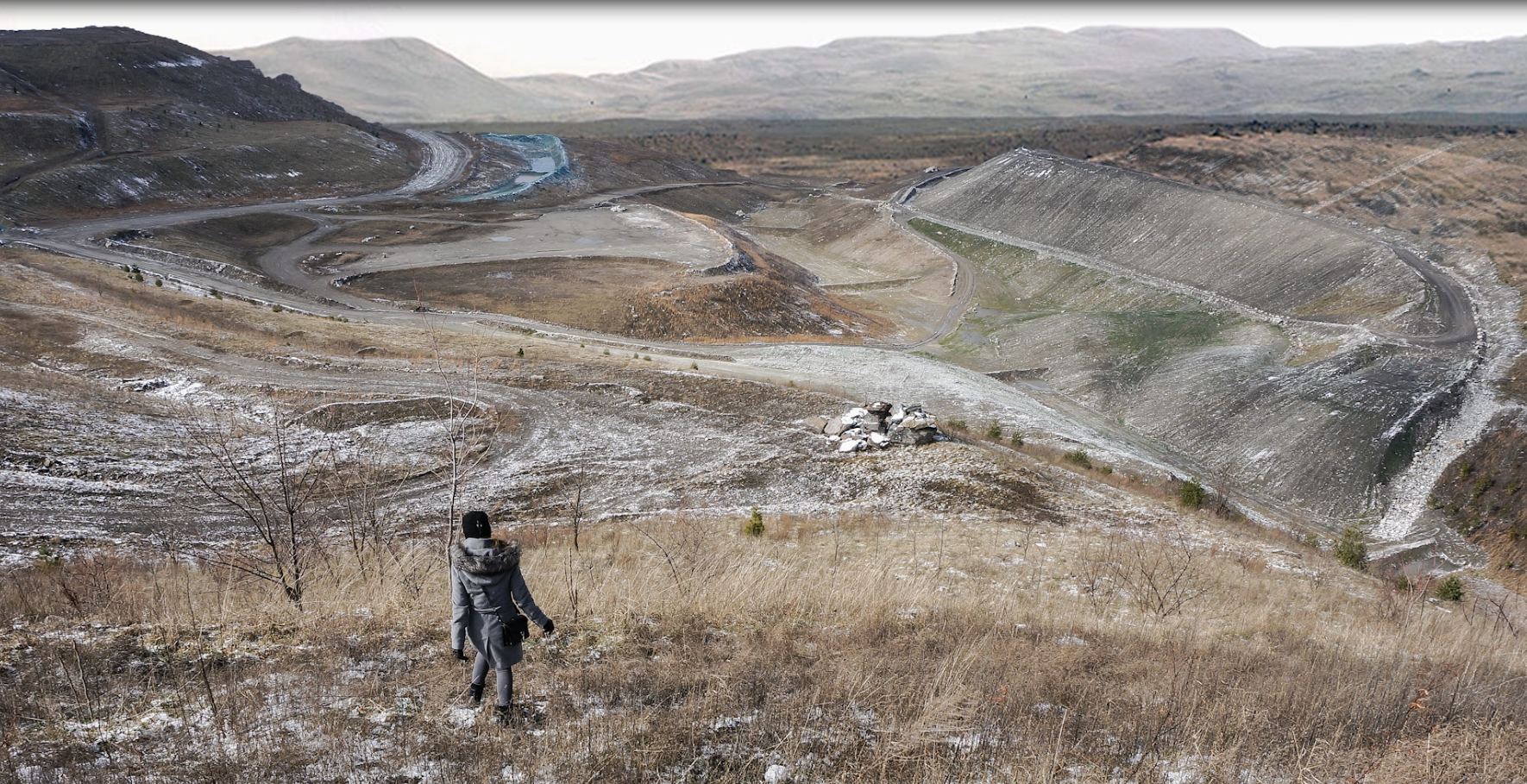
This short essay is a reflection on territories and (interpretative) gazes. The title I use is a quotation from Baudrillard’s America.[1] It evokes, today, the urgent need to reconnect the intellectual work of architects and planners to reality and its mystery.[2] More specifically, it is an attempt to clarify how we work, what we do to start an investigation on space, when that very space we wish to explore and to understand is far beyond the scope of our exhaustive comprehension, when our capacities are clearly insufficient to cover its complexity. When our traditional tools appear inadequate and our time forcefully limited. When the scale is vast and far beyond the architect’s and urbanist’s domain. When, in fact, the problem cannot be tackled with the tools we have to hand. I believe we often, if not always, act, take decisions, design in similarly incomplete frameworks. The case I will consider here is simply an extreme one: due to the immense difficulty in dealing with it from the social and economic point of view, despite the enormous amount of research on social and economic aspects, due to the gravity of the ecological crisis that affects it, although an important body of knowledge and denunciations of its manconstructed ecological problems already exists. Finally, due to the fragmentation and scarcity of studies concerning its space, its physical configurations in relation to social, ecological, and economic issues: the space we live in and we live with. Space as capital, space as support, the space of coexistence. It is in this space that America “counterposes its empirical radicalism, to which it alone gives dramatically concrete form”[3] to the utopian European tradition. This contribution is also the prolongation of a research on the North-Eastern American City,[4] a mythical dispersedly urbanized region, a “megalopolis,” as Jean Gottmann[5] defined it in 1961: from the coast to the Appalachian ridge, a strongly unbalanced territory, where the possibility of a counter project is explored, as in The New Exploration of Benton MacKaye (1928).[6]
Antefact: Territorialism. The “code of separation”[7] among bodies has worked deeply in the American context. The city is a juxtaposition, more than a superposition and interplay of spaces, it is made of territories differently appropriated by groups and individuals. It is the result of a harsh social play which produces a “democratic deficit” in North American megalopolitan and urban space. The city compels us to question the role of architecture, landscape, and urban design in solving or mitigating this deficit. It is a particularly intriguing question for the American territory, which has been often explicitly referred to, at least since Tocqueville,[8] as a space of freedom and democracy. The tension between the idea of a democratic space and the imperfection of this representation and concrete realization has been the starting point of the investigation, prolonging the research “Inside A New Form of Dispersed Megalopolis,”[9] and through the spatial lens inspired by Eliot and Baxter’s open space projects for the Boston area, as a means of combating slums and providing a framework for guiding future evolutions.[10]
© UVA, Design studio; 2017.
Design, here, is a double-edged sword. It is an agent working for a better world. A Saint George defending the princess and liberating the city, as Bernardo Secchi acutely framed out in his analysis of the urbanistic discourse:[11] If we trust its good faith and its capacity to reach a deep reading and understanding of each situation, design would reveal the specificities and potentials of the same.[12]
On the other hand, and in an exercise that might perturb our intellectual tranquillity, the traditional reading can be inverted, highlighting the responsibility of spatial design and the project in worsening the population’s general conditions of life. Architecture and urbanism are here observed for their responsibility in producing injustice, spatial injustice in particular.[13] Bernardo Secchi unequivocally posits this hypothesis in his last book.[14]
After having investigated some of the fractures, absences, and exceptions in the portion of the megalopolis in the Boston area (old mill towns, latino ghettos in search of a new role in the metropolis, “servant” territories where spatial and environmental injustices overlap; marginal places on the mountain ridges where industrial abandonment emphasizes the interruption of the supposed continuity of the megalopolitan space)[15], and the “core materials,” the generic socio-spatial devices of the American city (the vast middle class suburbia, its system of clusters along railways and highways, their landscape, infrastructures, lifecycles, challenges and crises), along an east-west section through the Boston Metropolitan area,[16] Appalachia, the vast hole in the Megalopolitan space, features as the case in point.
© UVA, Design studio, 2017
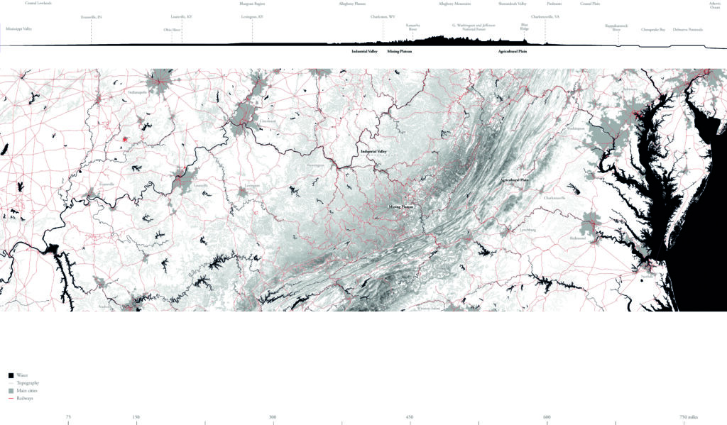
Towards a Research on Appalachia. Appalachia is the object of the exploration. Mapping, with a focus on the literary gaze, explorations on site, defining first elements for building scenarios about the future of Appalachia are the operations that have been realized. In doing so, we explored an eastwest transect, a territory crossing Virginia and West Virginia, between Charlottesville and Milton (fig. 2).
“Physiography,” “Palimpsest,” “Resources” are the keywords that organize an initial “Atlas of Appalachian space:”[17] they interrogate the complex nature of this immense region, the stratification of its territorial rationalizations and exploitation techniques in relation to settlement patterns, as well as the correlation with economic, social, demographic issues and infrastructure. They witness the profound shift in the orientation of our gaze while describing the space of Appalachia.

© UVA, Design studio, 2017
In “Physiography,” the attention is on the work of water and topography, on the erosion of the Appalachian plateau which has revealed the edges of coal seams; the carving of larger waterways opened up the territory for navigation and settlement; the crinkled topography has acted as a check on the growth of large-scale agriculture and settlement; water and topography are associated with the richness in biodiversity, as northern species forced south by advancing glaciers found refuge in the mountains.
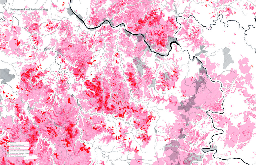
The “Palimpsest of Exploitation” describes the coal mining and the stratification of techniques, waste, destruction and inhabited sites fully integrated into the mechanism of exploitation: a cultural landscape constructed first by European settlers who migrated west into territory inhabited by the Iroquois, Cherokee, Shawnee, and Chocktaw. Industrial-scale extraction practices have indeed transformed the territory—physically, politically, economically, and culturally (figs. 3–4). Today, that relationship has only become more complicated and destructive. Before the coal-powered steam engine, deforestation denuded West Virginia to fuel a growing colonial population. The introduction of steel manufacturing drove the first iteration of coal mining in the region, extracting accessible coal from visible coal seams in the sides of the slopes. When the accessible and visible portions of the coal seams were tapped out, mining companies engineered a way to reach the rest of the deposit by removing the tops of the mountains and filling nearby valleys with the overburden, a practice that had drastic effects on the region’s watersheds.
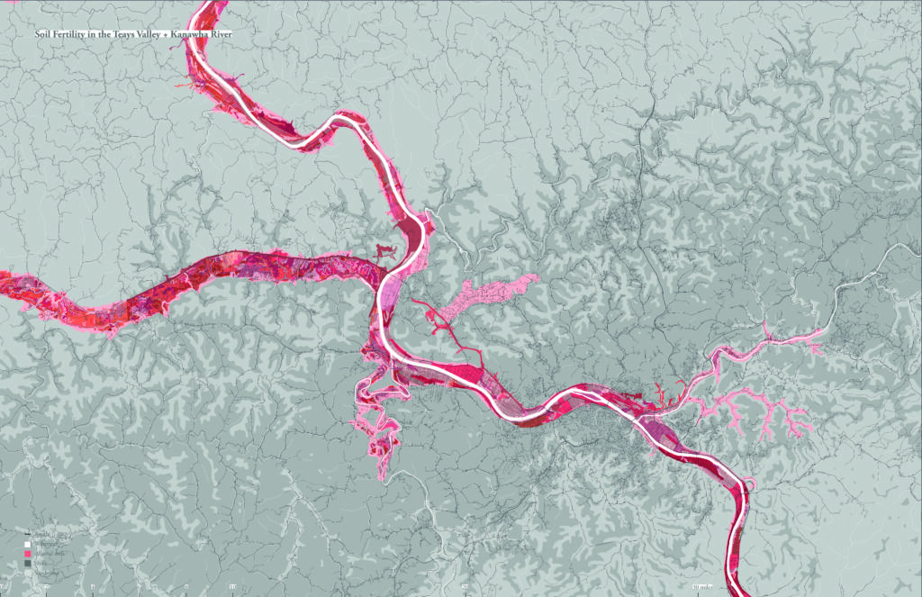
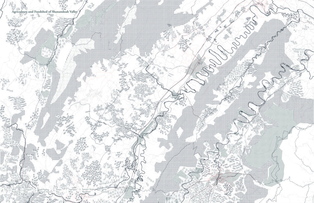
The “Resources” we describe are not only the traditional ones. Alongside the story of coal, the Shenandoah Valley, once known as the “Breadbasket of the Confederacy,” is home to extensive mechanized farming practices, which produce large parcels of corn, soy, sorghum, and grains for cattle feed, while the best soils (on the gentle slopes) are considered too difficult for such practices and are left aside (figs. 5–6).
© UVA, Design studio; 2017
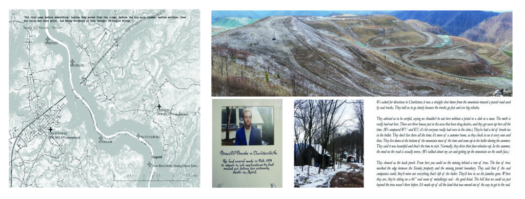
The central strip in the middle of the Atlas, as organized in the final exhibition, tells microhistories collected ‘on the road,’ through episodes of fieldwork, sketches, interviews, quoting novels, taking pictures, listening to the different voices of Appalachian music. Mapping the literary gaze has been a short-cut to an involvement that helped us gain a deeper understanding of the region.
The third and final part, “Scenarios,” opens to how we might imagine the future: it is an act of empirical and utopian radicalism. The questions are vast, many, and contrasted: how to understand the consequences of a future of Appalachia dominated by its exploitation? Can we reverse this longterm tendency into a new project of co-habitation, thinking “like a mountain?” Finally, if Appalachia is prisoner of its strong and often negative images, a topos in America’s collective imagery,[18] what if we were to lay less emphasis on the signs of homogeneity than in the past, showing spaces inhabited by populations of many different cultures, not just the hillbilly, poor white stereotype so often conveyed by the media?[19]
© UVA, Design studio; 2017
The first scenario, “Extracting Appalachia, the Paradox of Plenty,” imagines work with design tools to recover the destruction of a persisting logic of resource extraction. The radical scenario of “Autarchic Appalachia,” the second one, envisages a post extraction future for Appalachia and one of radical coexistence between humans and non-humans. The last scenario, “One, No One, One Hundred Thousand,”[20] proposes to deconstruct Appalachia and multiply its own variety of situations and images, letting a space of differences emerge.[21] It is based on the hypothesis that megalopolises developing at the border of mountains might interact and integrate parts of Appalachia, reinforcing the ongoing and emerging relations. In three different ways, the scenarios address the question of equality in space and in a territorial perspective.
Urbanism as a Research Tool
“I lean back, try to forget these fields and flanking hills. A long time before me or these tools, the Teays flowed here. I can almost feel the cold waters and the tickling the trilobites make when they crawl. All the water from the old mountains flowed west. But the land lifted. I have only the bottoms and stone animals I collect.”
(Breece D’J Pancake, “Trilobites”)[22]
Crossing Virginia and West Virginia along an East-West transect, the thought initially goes to William Least Heat-Moon’s travels across the US, nourished by an almost desperate sensation of isolation and the growing awareness of being in a foreign land.[23] The territory crossed by the author looks like a vast battlefield of cultural and ecosystem erasure; a place of conflicts and destruction, of forms of resistance hidden in the voids of the immense space crossed by the Blue Highways. In fact, there is not “only” description, but the denunciation of the nonsensical environmental disaster generated by an ignorant idea of progress and a lot of nostalgia. The journey and the landscapes can be read as an allegory, “speaking other,”/“seeing other,”[24] that enriches sense with sense: to the real trajectory it corresponds an intimate one—of rediscovery and rebirth—together with a collective trajectory, of a mobile population continuously transforming itself within the American continent, in search of a relation, in space, between and amongst time, men, and events. The “literary gaze” and the travel have focused on one author, Breece D’J Pancake, and his set of novels on Appalachia published posthumously in 1983,[25] to organize the fieldwork, retracing written matter and places: mapping the writer’s world[26] (fig. 7), his home town, Milton, the buried valleys of the old Teays river in West Virginia, the geological features he describes in “Trilobites.”
Although extreme efforts were made at the national level to overcome the tragic situation of poverty in Appalachia[27], each novel and each sentence highlight a chapter of a constructed path to dependency.[28]
© UVA, Design studio; 2017
Maps and Microhistory
“I pass an iron sign put up by the WPA: ‘Surveyed by George Washington, the Teays River Pike.’ I see fields and cattle where buildings stand, picture them from some long-off time.”
(Breece D’J Pancake “Trilobites,” 1977)[29]
Mapping Breece D’J Pancake’s literary world and realizing the Atlas gives visible shape to the inherent spatiality of our lives, it is “… intentional spatialization that aims to bring to the interpretative surface the fundamental and allembracing, but frequently buried or backgrounded spatiality of human life.”[30] The Atlas and the micro-histories[31] referred to the novels or to exchanges we had with people on the road, close to extraction sites (the recent, terrifying, top mountain removal technique), or in a deserted high street in Milton, people who hope to leave, or remain without hope, where individual life-trajectories cross largescale socio-historical problems. It was the case in the exchange with Breece’s schoolmate who came back because of her family and who is today the head of the public library in Milton, or talking to a middle aged man who decided to spend his retirement on the Blue Ridge, working as a volunteer for the Appalachian Trail, because of the presence, in the nearby cities, of hospitals and the cheap cost of living compared to the coast where he came from.
Maps and written matter work in dialogue and merge close and distant readings. Examining the US on a vaster scale the singularity of Appalachia persists, both in the social and political sense, geology and society seem to be connected in bitter determinism. The high rate of drug addiction is confirmed when compared to the map of the US and is mentioned by each and every person we meet (fig. 8). The condition of isolation and exclusion and is visible even in the details of the very “light,” all too light, urban infrastructure. In space we read the concrete conditions offered to life and injustice in the design of the space in which they live. As Dike. points out, the focus is on the process in which spatiality is “a producer and reproducer of, and at the same time being produced and reproduced by, relatively stable structures (permanences)”; secondly considering that justice and spatiality interrelate “through a mediation of larger permanences that give rise to both of them.” [32] The democratic deficit does not only concern the spatial distribution of services or accessibility, but the consistency of space, questioning the entire process of path dependency construction.[33]

© UVA, Design studio; 2017
Reading Cycles/Re-Cycle. A cycle is described by a pattern. If this is true, we can describe spatial patterns which are connected to specific cycles (technological, economic, ecological, cultural, etc.). As in the old mining cities of Appalachia, the company towns and the mines repeated their patterns hundreds of times over, and when the cycle is over the physical deposit remains, but new cycles need to be imagined.[34] They are, in fact, “temporary structures within the historical flow,”[35] in between the “event” and the “longue durée,” “cycles are the—manifestly unstable—border country between them. Structures, because they introduce repetition in history.”[36] In the case of Appalachia each economic cycle has shaped the region, occupied and colonized space, abandoned it, exploited sites with different techniques. The cycle, then, has shaped space while highlighting time, it is a chronotope[37] and a process at the same time. Reading cycles in space is also needed to describe the different forms of rationalizations, their technicality and spatiality; they are permanent, but provisional, limited in time, repetitive, although different. Closed cycles (of exploitation, of urbanization, …) remain on the ground and become part of the palimpsest, while new cycles have to be imagined, which often reproduce the same uneven development (in this sense, although different, they repeat themselves). It is in the idea of breaking this process of the reproduction of injustice that the scenarios have been imagined.
No conclusions. This short essay on territories, spatial injustice and interpretative gazes has no conclusions or, better, no “happy end,” if not the idea of using urbanism as a research tool to unveil the processes here only briefly sketched and to imagine different worlds. The need is to work with the hardness of space, both its inertia and the open trajectories it contains. It is in the concrete matter of which space is made that fractures can be recognised, porosities revealed.
[1] Jean Baudrillard, America, trans. Chris Turner (New York, 1988).
[2] This is an account of the two months I spent at Virginia University as Thomas Jefferson Visiting Professor in 2017. The attempt has been to compact the experience of a Design Studio in an intense shorter period. I want here to thank Inaki Alday, Ed Ford, Margarita Jover, Alex Wall (also for suggesting the reading of Breece D’J Pancake) and all the colleagues who have fully supported this “extreme exercise.” A special thanks and my gratitude go to the students (Batul Abbas, Joshua Aronson, Joseph Brookover, Luke Harris, Laurence Holland, Jennifer Hsiaw, Elizabeth Kulesza, Lemara Miftakhova, Shannon Ruhl, Christian Storch, Xiang Zhao, Bonnie Kate Walker) for their acute and engaged participation and to Anthony Averbeck, Lecturer UVA, Roberto Sega, Visiting Ph.D. EPFL, for their precious help. The teaching has been accompanied by a series of lectures divided into two parts: the first on the role of design, the second on a new research project in progress on bio-political space.
[3] Baudrillard, America (see note 1), 98.
[4] See Paola Viganò, Territorialism (Cambridge, MA, 2014).
[5] See Jean Gottmann, Megalopolis: The Urbanized Northeastern Seaboard of the United States (New York, 1961).
[6] As is well-known, the Appalachian Trail was not only conceived by Benton MacKaye as a path on the ridge of the Appalachian chain, but had the ambition to reverse the organization of the territory, bringing development where resources were extracted.
[7] Baudrillard, America (see note 1), 33.
[8] In Democracy in America, at the beginning of the rightly famous introduction, Alexis de Tocqueville states: “Amongst the novel objects that attracted my attention during my stay in the United States, nothing struck me more forcibly than the general equality of conditions.” Alexis de Tocqueville, Democracy in America (Hertfordshire, 1998), 7.
[9] GSD, Option Studio fall 2012 and fall 2013.
[10] In the Boston Metropolitan Park Report of 1893, the commission’s secretary Sylvester Baxter and landscape architect Charles Eliot presented an approach to urban design by looking at the city through the picturesque natural open spaces at its margins. As Steven T. Moga points out: “I argue that Eliot and Baxter viewed open space planning as a means of combating slums and establishing a region-wide land use template for future growth.” Steven T. Moga, “Marginal Lands and Suburban Nature: Open Space Planning and the Case of the 1893 Boston Metropolitan Parks Plan,” Journal of Planning History 8, no. 4 (2009): 308–329.
[11] Bernardo Secchi’s Il racconto urbanistico is a fundamental analysis of the construction of the urbanistic discourse—its metaphors and concepts—around the idea of a process of improvement of the population’s general living conditions. See Bernardo Secchi, Il racconto urbanistico (Torino, 1984).
[12] “Injustices occur when human law and social practice ignore natural processes and when those who plan, design, and build the city focus on a neighbourhood’s problems and fail to recognize its resources.” Anne Whiston Spirn, “Restoring Mill Creek: Landscape Literacy, Environmental Justice and City Planning and Design,” Landscape Research 30, no. 5 (2005): 395–413, esp. 395.
[13] See Edward Soja, “The City and Spatial Justice,” Justice spatiale/Spatial Justice, no. 1 (2009), http://www.jssj.org (accessed October 16, 2018).
[14] Bernardo Secchi, La città dei ricchi e la città dei poveri (Roma and Bari, 2013).
[15] GSD, Option Studio fall 2012.
[16] GSD, Option Studio fall 2013.
[17] Among the oldest mountain systems on Earth, made of mountains, valleys, ridges, and plateaus separated by the coastal plain by a massive fall line. The Blue Ridge is the backbone of the system. Between the Blue Ridge and the Fall line, lies a rolling plateau called Piedmont. The region includes 420 counties in 13 states. It extends more than 1,000 miles, from southern New York to north-eastern Mississippi, and is home to more than 25 million people. From one region of widespread poverty to one of economic contrasts (see the ARC – Appalachian Regional Commission – website). See also the comparison with the 1964 study on Appalachia realised on demand of John F. Kennedy (Appalachia: A Report by the President’s Appalachian Regional Commission, https://www.arc.gov/noindex/aboutarc/history/parc/PARCtoc.pdf) See also Andrew Isserman, “Appalachia Then and Now: An Update of ‘The Realities of Deprivation’ Reported to the President in 1964,” Journal of Appalachian Studies 3, no. 1 (1997): 43–69.
[18] The beginning of the introduction to the 1964 report to the President is: “Appalachia is a region apart—geographically and statistically.” Appalachia XV (see note 17).
[19] On the role of such stereotypes see: James D. Vance, Hillbilly Elegy: A Memoir of a Family and a Culture in Crisis (New York, 2016).
[20] The title chosen for the scenario dealing with the multiplicity of Appalachian space is inspired by one of Pirandello’s most famous novels.
[21] This was still the main interpretation in 1964. From Appalachia: A Report by the President’s Appalachian Regional Commission: “Appalachia is more striking in its homogeneity than in its diversity,” XVIII. In Isserman’s Appalachia Then and Now this interpretation becomes more nuanced and even clearly contradicted. See Isserman, Appalachia Then and Now (see note 17).
[22] Breece D’J Pancake, “Trilobites,” in The Stories of Breece D’J Pancake (New York, 1983), 25. The story was first published in The Atlantic in 1977.
[23] William Least Heat-Moon, Blue Highways (Boston, MA, 1983), 10. The journey lasts three months across a vast territory, in search of worlds where change is not synonymous with ruin, where time, men, and events are in relation to each other.
[24] “Le ‘dire autrement’ de l’allégorie (allegorein) s’origine dans un ‘voir autrement’.” See Christopher Imbert and Philippe Maupeu, eds., Le paysage allégorique (Rennes, 2011), 10.
[25] See Breece D’J (Dexter John) Pancake, The Stories of Breece D’J Pancake (New York, 1983).
[26] See Franco Moretti, Atlante del romanzo europeo (1800–1900) (Torino, 1997). Moretti insists on the ability of mapping to reveal otherwise invisible relationships and connections. We can only agree. On the other hand, for architects and urban planners, the available literature constitutes a vast arsenal of themes and interpretations that are often capable of going beyond conventional wisdom. In many of the projects on which we have worked, considering the literary gaze has played a fundamental role in design interpretation. See, for example, Bernardo Secchi and Paola Viganò, Etude pour le Val de Durance.
[27] Appalachia was central to President Lyndon B. Johnson’s “War on Poverty,” declared in 1964 in reaction to the growing income inequality in the United States, that Johnson framed as “the defining challenge of our time.” For a critical overview of the related policies in the Appalachian context, see Ronald D. Eller, “The War on Poverty in Appalachia,” University of Kentucky, 2014, http://www.uky.edu/CommInfoStudies/IRJCI/EllerPovertyWarAppalachiaOhioU.pdf.
[28] See Paul Salstrom, Appalachia’s Path to Dependency: Rethinking a Region’s Economic History, 1730–1940 (Lexington, 1994).
[29] Pancake, “Trilobites” (see note 21), 24. The reference here is to the Works Progress Administration (WPA), renominated as the Work Projects Administration in 1939, a clear political program, the most ambitious American New Deal agency, realizing public buildings and roads employing millions of unemployed people to diffuse welfare facilities and infrastructures in almost every corner of the US. In Appalachia, the effort in infrastructures construction continues with the “War on Poverty,” in policies to foster economic development against geography.
[30] Edward Soja, Postmetropolis (Oxford, 2000), 15.
[31] For the microhistories the reference is to Carlo Ginzburg and Giovanni Levi, but also to George Stewart. See Carlo Ginzburg, “Microhistory, Two or Three Things That I Know about It,” Critical Inquiry 20, no. 1 (1993): 10–35; Giovanni Levi, “On Microhistory,” in New Perspectives on Historical Writing, ed. Peter Burke (Cambridge, 1991), 93–113, and George R. Stewart, Pickett’s Charge: A Microhistory of the Final Attack at Gettysburg, July 3, 1863 (Boston, 1959).
[32] Mustafa Dike, “Justice and the spatial imagination,” Environment and Planning 33, no.10 (2001): 1785–1805.
[33] In commenting the fifty years of ARC actions, mainly on infrastructures, Ronald D. Eller writes: “Like other Great Society legislation, ARC policies have concentrated resources in a select few ‘growth centers’ in the region, expanding services to the poor and growing the mountain middle class, but doing little to alter conditions in the most rural distressed counties or to address systemic political or economic inequalities throughout Appalachia.” Viewing Appalachian culture as being anachronistic, “programs designed to provide jobs and to develop the region’s economy concentrated resources in middle-class growth centers, in failing to protect the landscape and water quality, encouraged the growth of consumer dependency, and facilitated the outmigration of youth.” Ronald D. Eller, “The War on Poverty in Appalachia,” University of Kentucky, 2014 (accessed October 17, 2018), http://www.uky.edu/CommInfoStudies/IRJCI/EllerPovertyWarAppalachiaOhioU.pdf. See also Ronald D. Eller, Uneven Ground: Appalachia Since 1945 (Lexington, 2008).
[34] See Paola Viganò, “Riciclare citt.,” in Re-cycle, ed. Ciorra Pippo and Marini Sara (Milano, 2011) and Paola Vigan., “Lifecycles, Embodied Energy, Inclusion: Elements for a Theory of the City as Renewable Resource,” in Recycling City, Lifecycles, Embodied Energy, Inclusion, ed. Fabian Lorenzo, Giannotti Emanuel and Paola Vigan. (Pordenone, 2012).
[35] Franco Moretti, “Graphs, Maps, Trees: Abstract Models for Literary History 1,” New Left Review 24 (2003): 67–93, esp. 76.
[36] Ibid.
[37] Bakhtin’s term refers to the “intrinsic connectedness of temporal and spatial relationships that are artistically expressed.” Mikhail M. Bakhtin, Forms of Time and of the Chronotope in the Novel, in The Dialogic Imagination: Four Essays by M. M. Bakhtin (Austin, TX, 1981), 84.